


Development of Boulder's Multimodal System
Boulder, Colorado
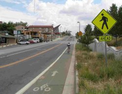
Source: Pedestrian and Bicycle Information Center (PBIC)
Problem
What steps must a city take once its leaders decide to encourage more transportation options to reduce reliance on car travel?
Background
In the late 1980s, Boulder's City Council considered what would be needed — financially, physically, and in quality-of-life terms — to continue to expand the city's roadway system. The council decided that Boulder would provide mobility not through new roads, but through a wide array of transportation choices to make it easy not to drive. Today, Boulder enjoys an 8.8 percent bicycle mode share, according to the 2006 American Community Survey, compared to a nationwide average of 0.5 percent. The city estimates that its bicycle and pedestrian system is 85 percent complete.
The reasons for Boulder's success can be classified into two categories: Good bones, those built-in advantages that are hard to replicate if they're not already in place; and actions taken over the last twenty years to provide real transportation choices to residents, workers and visitors.
Solutions and results
Boulder has leveraged natural advantages with a significant commitment, well-designed plans, and resourceful follow-through to build a multimodal system and institutionalize the accommodation of bicycling and walking on many levels.
Natural advantages: underlying conditions that favor bicycle and pedestrian modes
University. The University of Colorado (CU) has 30,000 students in a community of 100,000 people. The existence of a university creates a built-in population less inclined to drive, more educated and often more progressive. It helps that CU's transportation policy and priorities have been fairly consistent with those of the city. Boulder focuses on building partnerships with the university, as well as the local school district, major employers and other agencies such as Boulder County, to provide meaningful travel choices that are seamless as they cross jurisdictional boundaries.
Growth boundary. Coordinating transportation programs with land use and planning is essential. Boulder began buying open space in the late 1960s and has amassed 43,000 acres that serve as a physical buffer around the city. The city also collaborates with Boulder County on a forward-thinking comprehensive plan, which focuses growth within existing city boundaries. As a result, most of Boulder's growth is in-fill and redevelopment, which increases density and multimodal-friendly urban forms. This pattern has allowed Boulder to spend its dollars on providing transportation choices rather than building new roads to serve sprawling developments. The city's relatively small size, about twenty-five square miles, means that almost any destination within the city can be reached by a bicycle trip of five miles or less.
Plan and follow up: building on natural advantages
Plan. The Boulder City Council adopted its first Transportation Master Plan (TMP) in 1989. Later revisions to the plan set ambitious goals of having only 25 percent of trips made in single-occupant vehicles by the year 2025 and of keeping vehicle miles traveled (VMT) at 1994 levels. The city recently updated its VMT calculations and is close to keeping VMT growth flat, in contrast to most of the rest of the Denver region and the country. In the TMP update of 2003, Boulder adopted the concept of complete streets and made a commitment to direct most transportation funding towards accommodating all modes on major corridors. Having a clear plan gives staff a blueprint to follow every day.
The HOP, Boulder's first high frequency service, connects three main activity centers: downtown Boulder, the Twenty-Ninth Street shopping district and the University of Colorado.
Image: GO Boulder
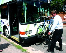
Act. Boulder has a strong transit system with buses running on 10-minute frequencies on several major corridors, and over 30,000 transit trips a day in a community of 100,000 people. The city works closely with RTD, the regional transit provider, to provide direct routing on friendly, branded, appealing vehicles, and spends about $1.5 million annually for additional service on high frequency routes. All-access transit pass programs (Eco Passes for businesses and neighborhoods and the CU Student Pass) help fill the seats. The city offers a subsidy to businesses new to the Eco Pass program (50 percent in year one, 25 percent in year two), and an on-going subsidy of 30 percent to help neighborhoods participate. Boulder spends approximately $175,000 on these subsidies annually, which help catalyze nearly $5 million in other local spending on the passes.
Local services that began with the HOP and SKIP routes have expanded to provide links to the regional routes JUMP, DASH and BOLT. GO Boulder works closely with Boulder East, a local transportation management association, to support a network of nearly 400 employee transportation coordinators (ETCs) at local businesses. Recent projects with ETCs include an effort (funded with federal Congestion Mitigation and Air Quality dollars) to increase the pick-up rate of Eco Passes, since city research has shown that Eco Pass holders are five times more likely to use transit than non-holders.
Boulder has over 100 miles of multiuse pathway with 74 underpasses allowing uninterrupted travel through much of town. Since 1989, the city has added to the system each year, on average, one mile of off-street path, half a mile of on-street bicycle lanes, and two underpasses. Ninety-five percent of major arterials have bicycle lanes or adjacent pathways. The off-street system is complemented by an additional 200 miles of dedicated on-street facilities that include bicycle lanes, signed routes and bikable shoulders. Bicycle paths and bicycle lanes have equal priority with the city's major street system for maintenance and snow control.
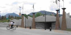
Boulder reconstructed the approach and facade of this underpass connecting off-campus student housing to the main CU campus. The project set back the opening to improve site distance and installed a raised intersection crossing of the road. New artwork celebrates this gateway to the campus and makes the underpass inviting to users.
Image: GO Boulder
Evaluate. Measurements allow changes and progress to be tracked over time. This is important because often public perceptions are not aligned with reality. People may think, "Traffic is up; it takes forever to get across town; nobody rides the bus; the city doesn't spend any money on cars." Evaluation generates data that allow planners to bust myths, have real conversations about progress, and adjust their approach. Boulder uses a wide variety of tools to measure progress, including employee surveys, travel diary studies, estimates of vehicle miles traveled, and traffic counts. The city has automated loop detectors at 13 locations on the pathway system and has recently begun tracking the numbers of bicycles parked in the downtown area. The city's latest survey of employees shows that 53 percent of work trips by Boulder residents were made by single-occupant vehicles in 2006, down from 65 percent in 1995 (Transportation Metrics, Spring 2008).
Walk the talk. A city manages assets and implements policies through its budget. Even the best plan will not succeed unless resources are allocated in support of community priorities. In 2007 and 2008, Boulder devoted 49 percent of its transportation budget to bicycle, pedestrian, transit and transportation demand management projects. This number fluctuates over time as various major projects move forward, but each year sees a significant investment in multimodal projects. The increment devoted to multimodal projects is likely to grow in the future, as few roadway operation improvements and no roadway capacity projects are on the city's list of priority projects.
Build political support. People in Boulder are active, engaged, and like to debate everything. As a result, most significant projects are controversial, especially if taking a bit of travel lane or reducing parking is suggested. Projects often are scaled back or require additional investment to find a compromise, but the City Council moves most projects forward. Although advocacy and citizen support help, elected officials usually lead on these issues. Boulder's supportive political leadership, the high level of bicycle use, and the city's reputation as a mecca for outdoor-oriented businesses and elite athletes are integrally related and sustain an ongoing commitment to improvements. Identifying and encouraging future champions is essential to building more support.
Redefine the problem. Boulder's transportation engineers cheerfully and routinely design innovative and effective multimodal projects. Most come from traditional engineering backgrounds and were not particularly focused on designing for bicyclists and pedestrians when they were hired. One explanation for the transformation comes from engineer Michael Gardner-Sweeney, the transportation planning and operations coordinator for the city: "Engineers are problem solvers. If the problem is to move as many cars as possible through an intersection, that's what they'll do. If you define the problem differently, you get different results."
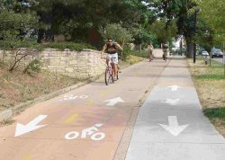
Broadway side path (top): Boulder designated this sidewalk along Broadway, an arterial that connects downtown to the CU campus, as a multiuse path. Markings and colored pavement separate bicycle and pedestrian travel flow. Where the path crosses Table Mesa Drive (bottom), the raised right turn by-pass crossing has improved compliance by motorists to yield the right of way and better facilitates eye contact between motorists and cyclists/pedestrians approaching the crosswalk. Note the signs warning motorists to expect bicycle/pedestrian traffic from both directions.
Image: GO Boulder
Boulder has redefined the problem to be one of moving people in a multimodal system, with a strong emphasis on bicycles, pedestrians and transit. This mindset has been institutionalized throughout the city's transportation division. Often when a project is planned on one of the several state highways that cut through the community, the city asks the state for permission to build narrower lanes or install innovative treatments. The city's engineers are adept at finding standards or producing crash and safety data that back up their designs. The state Department of Transportation (DOT) usually approves the city's requests, based on the validity of the information provided by the engineers.
Experiment and refine. The Boulder bikeway network includes a number of side paths along roadways. These paths, and an extensive system of multiuse greenway paths along riparian corridors, are heavily used by the city's cycling population. Various standards were used to design the city's side paths; some operate better than others. To address safety issues that arise when side paths cross roadways and driveways, the city has developed an array of tools including raised right-turn bypass islands, colored pavement and extensive signage. A recent analysis of bicycle- and pedestrian-related crashes by the state DOT shows that Boulder's side paths along roadways do not have higher crash rates than the on-street bicycle system. The relatively large number of bicyclists likely also reduces crashes, as bicyclists are expected users.
Correct mistakes. The eastern half of Boulder was developed after 1950, with the same unfortunate combination of superblocks, strip malls, shopping centers, big parking lots and intimidating arterials as most cities across the country. Boulder has been working to retrofit these areas. The city's biggest arterial is being transformed into a complete street, with a variety of treatments on different sections of the corridor: bicycle lanes on the frontage road, multiuse pathways, shared bicycle and bus lanes, transit upgrades and pedestrian actuated crossing signals. It remains a big street, but now can be navigated on a bicycle or on foot with more comfort.
Changing land use takes longer. Boulder planners have put in place codes and zoning that will bring buildings back up to the street, creating pedestrian-friendly urban forms and reducing the number of curb cuts. The city is breaking up superblocks through redevelopment. The recent major renovation of a Target store included bicycle lanes past the front of the building. Striping bicycle lanes through parking lots may not be ideal, but the lanes connect through an adjacent shopping area to link to greenway paths in either direction. Through the development review process, the city recently asked a big upscale grocer to make parking access function more like a local street.
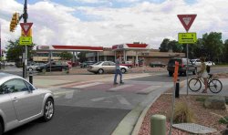
The 28th Street Transportation Improvement Project transformed this formerly auto-dominated roadway into a complete street that is now inviting and safe for bicyclists, walkers and transit users.
Image: GO Boulder
Leverage assets. In the mid 1980s, Boulder City Council directed staff to build a small section of path along Boulder Creek in the downtown area. The public loved it and clamored for more. That small section of pathway helped catalyze the Greenway System, a program with many goals including riparian protection and flood mitigation. The trail includes a spine pathway along Boulder Creek and connecting paths along its six tributaries.
Encouragement and education. Although people in Boulder can travel by bicycle comfortably and sometimes more quickly than by car, there isn't yet an Amsterdam-level of cycling. The city works on education and encouragement through GO Boulder, which handles transportation planning, policy and programs that support mode shift. GO Boulder recently launched GOBikeBoulder.net, an interactive bicycle routing Web site, and GO Smart, an individualized marketing program; it is exploring Velib-style bicycle rentals and Sunday Parkways. The city also partners with the local school district on Safe Routes to School; with Boulder East, a local transportation management association; and with US 36 Commuting Solutions, which focuses on travel along the major corridor between Boulder and Denver.
Staff are convinced that many more trips could be made by bicycle and foot, but changing the American mindset is difficult. As Boulder's Transportation Director Tracy Winfree says, "There is no silver bullet, but there may be a golden menu. Patience, persistence, coordination and on-going commitment are essential to building that effective menu of travel choices for a community over time."
Cost
The city's total transportation budget is approximately $20 million a year. The capital transportation budget is about $1 million a year, leveraged significantly with federal and private development funds. GO Boulder has a budget of $3 million a year and eight staff members.
The city has made a concerted and successful effort to leverage local dollars with federal funds, using Surface Transportation Program funds for several multimodal intersection projects that included operational improvements for cars, transit and bicycle/pedestrian facilities. Congestion Mitigation and Air Quality funds have helped to launch new transit services and fund innovative efforts like GoBikeBoulder, an on-line bicycle mapping service. Transportation Enhancement funds helped build several underpasses and pathway missing links. The city has averaged about $4 million annually in federal funds in recent years, though that is projected to decline.
Authors
Martha Roskowski, with Marni Ratzel, Michael Gardner-Sweeney and Tracy Winfree
Contact
Martha Roskowski
GO Boulder Program Manager
City of Boulder Transportation Department
PO Box 791
Boulder, CO 80306
(303) 441-4155
roskowskim@bouldercolorado.gov
Web sites
Transportation Master Plan: http://www.bouldercolorado.gov/index.php?option=com_content&task=view&id=331&Itemid=1201
Transportation use measurements: http://www.bouldercolorado.gov/index.php?option=com_content&task=view&id=467&Itemid=1657
City of Boulder Transportation Metrics, Spring 2008:
http://www.bouldercolorado.gov/files/Transportation/Transportation/city_of_boulder_transportation_metrics_030308.pdf
Greenway system:
http://www.bouldercolorado.gov/index.php?option=com_content&task=view&id=4985&Itemid=1189
GoBoulder: http://www.bouldercolorado.gov/index.php?option=com_content&task=view&id=8774&Itemid=2973
GoBikeBoulder: http://www.bouldercolorado.gov/index.php?option=com_content&task=view&id=8840&Itemid=3018
GoSmart Boulder: http://gosmartboulder.com/
Image sources
All images: GO Boulder